
Addendum to Minutes - Environment committee -20th January 2020
Comments and objections relating to 16/1564/OUT – Phase 1A Lincoln South East Quadrant Sustainable Urban Extension North Of Canwick Avenue
After due consideration, Bracebridge Heath Parish Council strongly object to planning application 16/1564/OUT.
Council object on the following grounds:
- negative and unmitigated effects on highways, highway safety and traffic generation;
- effect of the development on air quality and noise disturbance;
- effect on public drainage and water systems;
- deficiencies in social facilities and infrastructure;
- effect on listed buildings and views out of the existing village;
- adverse impact on nature conservation and biodiversity;
- layout and density of building design;
- lack of consideration for issues of climate change;
- insufficient evidence of an adequate public transport strategy.
General comments
As there have been significant changes to the site boundary Council believe that this should have been submitted as a new planning application. Extra areas have been added purporting to be related to a masterplan. If this application is passed it will become policy without having been part of the original planning application.
The lack of a robust and clear masterplan for the South East Quadrant (SEQ) means that there is no way of knowing how this application fits in with the overall plan for the area. This is contrary to the Central Lincolnshire Plan LP30 which states ‘It will be a master planned SUE that exploits its close proximity to Lincoln and the City Centre through appropriate linkages whilst also forming a distinctive new community of neighbourhoods that has its own facilities including shops, schools and employment.’ Without this masterplan the SEQ will be developed in a haphazard piecemeal fashion with a lack of vision and continuity. It will lead to the possibility of Canwick Heath and Bracebridge Heath becoming one huge settlement without separate identities. There is no evidence provided as to how this development fits in with a masterplan for the SEQ.
The inclusion of the proposed land for the primary school extension and the local centre in the application documents is misleading.
These areas are outside of the scope of this application and in the absence of a masterplan the commitment to the delivery of this infrastructure is questionable.
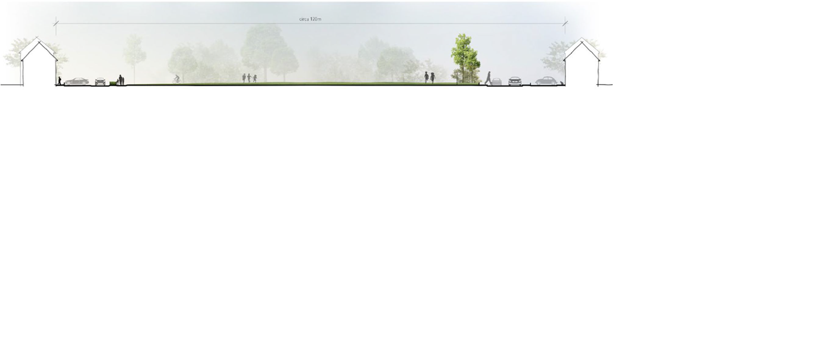
The strategic buffer zone shown on page 21 of the Design and Access statement (see image) is far too small. The 120m shown on the diagram below includes 2 front gardens, 2 roads and footpaths. Therefore, the actual green buffer zone is less than the length of a football pitch and less than half the width proposed in the emerging Bracebridge Heath Neighbourhood Plan. The proposed buffer zone between Bracebridge Heath and Canwick Heath is inadequate and will not will not provide a visual or physical separation between the settlements. This is contrary to 7.4.6 of the Central Lincolnshire Plan which states:
‘Respect for the character, biodiversity and landscape/ townscape contribution of the South Common and adjacent Bomber Command Centre Memorial, and the integrity and character of Canwick and Bracebridge Heath as distinct and separate villages’
Policy LP30: Lincoln Sustainable Urban Extensions states that the SEQ should provide: ‘A distinctive place to live that has its own character and physical identity and respects its local surroundings, including key views and vistas of and from Lincoln Cathedral and the historic core of the City, and across the Witham Valley including views of Lincoln from Heighington Road. It will contain different character areas and will have regard to the need to provide appropriate landscape setting for the existing villages of Bracebridge Heath and Canwick, together with the open area of South Common to the north;’
and
‘Extension of the existing green infrastructure network into multi-functional movement networks linking land uses, facilities and amenities which avoids the coalescence of the new community with Bracebridge Heath and Canwick villages’’ and ‘Improved linkages, enhancement and support of green wedges and other green infrastructure.’
CLLP Policy LP22 states that green wedges have been identified to prevent ‘the physical merging of settlements, preserving their separate identity, local character and historic character’
This planning application does not fulfil the requirements of Policy LP30 as it does not
- avoid the coalescence of the new community (Canwick Heath) with Bracebridge Heath;
- provide an appropriate landscape setting for the existing village;
- respect key views and vistas of Lincoln Cathedral (except along a busy principal road with no guarantee that the next piecemeal development will carry on that view/road);
- provide a continuation of the green infrastructure along Canwick Avenue to allow for it to join up to the copse at the bend inthe road at the parish boundary;
- provide strong connectivity to the city centre and adjacent communities through high quality safe and effective pedestrian and cycleway links.
Policy LP12: Infrastructure to Support Growth of the Central Lincolnshire Plan states: ‘All development should be supported by, and have good access to, all necessary infrastructure’. Bracebridge Heath school, is almost at full capacity, the doctors’ surgery is already full and the road structure is already struggling with the existing traffic load.
Without an agreed masterplan for the whole SEQ these policies cannot be adequately planned for or fulfilled. Bracebridge Heath Parish Council urge North Kesteven District Council and the applicant to consider the contents of the emerging Bracebridge Heath Parish Council Neighbourhood Plan. While it is not a made planning document, it is near completion and is currently undergoing its six- week statutory consultation.
Highway issues: traffic generation, vehicular access, highway safety
Council raise concerns about the Offsite Highways Mitigation Strategy. The document deals with each junction in isolation and has not looked at the proximity of existing and proposed junctions and the overall cumulative effect of these junctions on the highway. For example, the closeness of the following junctions:
- The proposed new roundabout at Lichfield Road entrance with the nearby need for a pedestrian crossing;
should be considered alongside
- the junction and pedestrian crossings at Canwick Avenue/London Road (A15) (there is approx. 480m gap between Lichfield Road and this junction);
and
- the junction at London Road and Grantham Road (A607) and the pedestrian crossing (approx. 310m gap between Canwick Avenue/London Road junction and this junction);
and
- the pedestrian crossing on Grantham Road linking Tesco and Co-op stores and carparks (approx. 55m gap between Grantham Road/London Road junction and this pedestrian crossing);
and
- the school crossing patrol on Grantham Road next to the school’s front playground entrance (approx. 43m gap between the pedestrian crossing and the school crossing patrol).
It is already common for the traffic to be backed up to the thirty mile an hour sign on Grantham Road and south of Dorothy Avenue on Sleaford Road. This is without the effect of the further proposed 1156 dwelling development on Sleaford Road and further developments on Grantham Road in the Cliff Villages to the south.
The cumulative effect of the developments on the highways will exceed the projected effect outlined in the application. Council strongly request that further work is carried out to determine the likely overall effect of traffic following the development of the SEQ, the development of the Church Commissioners application off A15, Sleaford Road and the effect of the Eastern Bypass on the village. The staccato and piecemeal approach to these developments will result in these issues being overlooked. Consideration for traffic flows and a more joined up approach is needed before this application is approved.
Other highway issues
It is noted that in the Off-site highways document (page 13), that it is considered that the Heighington Road with its new bridge over the Eastern bypass will be stopped up before it reaches Canwick as the access to Canwick Hill will not be viable with more traffic. This will have a detrimental effect on this and future SEQ developments as the increased traffic onto the B1188 will restrict traffic access onto that road from Canwick Avenue.
There is no provision for a light controlled pedestrian crossing on Canwick Avenue to allow parents and children a safe crossing to access the proposed primary school. Much of this road is within a forty mile an hour zone. Two pedestrian/cycle crossing areas will be needed:
- to cross to the green cycle lane area between the new roundabout and Bath Road; and
- to cross at the proposed roundabout at the junction of Lichfield Road and the proposed estate road.
The north side of Canwick Avenue does not have a footpath or cycleway to allow for the safe passage of pedestrians (including children) and cyclists along Canwick Avenue so that they can enter the estate safely.
The proposed roundabout at the junction of Lichfield Road, Canwick Avenue with the new access road will create a ’rat run’ in the St John’s development opposite as vehicles will try and avoid the roundabout by entering the St John’s development at Bath Road. The narrow estate roads were not designed for this usage.
At the south east edge of the site there is a green area which runs from Canwick Avenue to a shared private drive area. This will become a pedestrian ‘rat run’ to the proposed new school. Will there be a footpath here to facilitate this or will it be fenced off?
It is not clear whether the streets, lanes and shared access roads will have footpaths. This presents a safety risk to pedestrians and will be accentuated if the roads are not lit.
It is unclear if the streets and shared surface roads are designed to be adopted or un-adopted roads. If they are un-adopted, conflict will be caused by car parking along them as people access the recreation areas, Viking Way or primary school. It is also unclear how they will be managed or who will have ownership and responsibility for maintenance. Some homeowners may have to move their bins an unacceptable distance on the relevant days for emptying by refuse wagons. This will result in large, unsightly bin collection areas, many of which are adjacent to the recreation spaces. Could believe that all roads should be built to an adoptable standard.
If the proposed entrance road will be used to access further development to the north of this phase consideration should be given to the standard of build to ensure that it can withstand an increase in traffic in the future.
At the present time the school access road is a dead end. This will cause major safety issues. Despite all alternatives, parents will drive their children to school. There is nowhere for parents to drop off children or safely turn around. These roads and the surrounding residential streets will become clogged up twice a day.
What measures will be put in place to prevent parents dropping off children on Canwick Avenue opposite Bath Road so they can walk to school from there?
Council note the lack of visitor parking throughout the site. Visitor parking, possibly in the form of laybys, could prevent on street parking and allow the free flow of traffic and emergency services.
Traffic generation and road access
Until the masterplan for the whole of the South East Quadrant is completed, it is impossible to know how many more access routes to the site will be provided. The extent of queuing on the shown access road at peak times is likely to be significant and exit onto Canwick Avenue is likely to be slow. The number of proposed properties will lead to in excess of 400 additional cars on the local road network. This will negatively impact the existing roads which are already heavily congested throughout the day.
The current road infrastructure will struggle to cope with the additional traffic, especially the traffic light junctions of London Road with Canwick Avenue and the junction of Sleaford Road with Grantham Road.
The effect of the proximity of the traffic lights at the junction of London Road and Canwick Avenue is a concern. Traffic can regularly queue to reach this junction from Lichfield Road or beyond at peak times. Access to and from a roundabout on the junction on Lichfield Road and Canwick Avenue will be affected by this queuing traffic and Bath Road will undoubtably become a rat-run for local traffic.
Cycleways
The provision of cycleways throughout the site is welcomed, however they are cycleways to nowhere. A contribution is needed to ensure cycleway continuity within, to and from the proposed development. Current proposals are contrary to CLLP LP30 which states there should be ‘Strong connectivity within the development and to the City Centre and adjacent communities through high quality, safe and effective pedestrian and cycling links.’
Consideration and financial backing must to be given to enable access to Bracebridge Heath, Canwick and Lincoln City Centre via a cycle path. The area needs to be fully investigated and the local topography needs to be taken into account when looking at proposed routes.
How will safety be ensured for pedestrians and cyclists along these cycleway/footpaths especially after dark? A lighting policy needs to be in place before this planning application is approved.
Air quality, noise and disturbance
The site of the school next to Canwick Avenue with its associated vehicle pollution and noise problems is unacceptable for the health of young children.
Traffic noise from Canwick Avenue will cause problems for the school. This will lead to increased building costs. Air conditioning will need to be installed as windows will not be able to be opened due to the noise and air quality.
Air quality is already a problem in Bracebridge Heath with the junction of the A15 and A607 ranked as one of the worst areas for poor air quality (NKDC Air Quality Annual Status report 2018). The additional traffic caused by this development will increase waiting times at the London road traffic lights and the lights at the junction of A15/A607 along with waiting times at the new roundabout thus increasing pollution. This will not be mitigated by the new Eastern bypass as the access point that will be used is on Sleaford Road necessitating travel through the village.
Hazardous Materials.
It is noted and welcomed that properties will be built with a means of dispersing Radon Gas so that it does not build up within the properties.
Capacity of public drainage or water systems
It is stated that the ground is fairly flat indicating there is not enough gravity flow for sewage removal without pumping. There is no indication on the masterplan of where any pumping stations will be located and where connections with the main sewage system will be. It is understood that the existing sewerage system is close to capacity.
This will also affect the efficiency of SUDS. Pumping will be needed to facilitate runoff or the site will be at risk of standing water or floods. This risk is likely to increase as concrete, tarmac and other non-permeable surfaces are installed. It appears that infiltration tests have not been carried out prior to the application and there has been no liaison with Anglian Water in this matter. It is essential Anglian Water are approached for their views prior to this application being considered.
Application 15/0477/OUT indicated that clean water pressure was at its limit. The combination of this earlier application alongside the current application 16/1564/OUT suggests that this issue needs to be addressed with Anglian Water before any decision is made on this planning application.
SUDS (Infiltration Basins)
The three SUDs on the southern boundary of the site are on higher ground than the majority of the rest of the site. The SUD by Whitehall farm is also on higher land and will have limited gravity feed to it. How is runoff expected to run into these SUDS?
The permeability and infiltration rates of the ground in this area is variable. No work has been done on the infiltration rates of the proposed SUDS or who will maintain them. Investigation and documentation should be provided before planning permission is granted to ensure that the SUDS will function appropriately.
Council note the safety risk of some of the SUDS. Particularly those located along Canwick Avenue as they are on the pedestrian route to the proposed school. Council request that safety measures are considered.
Lodge Farm is a listed building. Some attempt has been made to conserve its historic environment. However, there are concerns regarding the close proximity of the SUD. Any overflow from this SUD is likely to be directed towards the farm.
As can be seen from recent wet weather, the surface runoff is of considerable concern to nearby villages both on the lee side of the escarpment to the east and the spring line to the west. Until the effect of surface water discharge has been investigated and satisfactorily resolved, this application should be refused.
Deficiencies in social facilities and infrastructure
The proposed S106 agreement is not sufficiently robust to combat the adverse effects of this development. It is noted that there appears to be no provision of a children’s play park with equipment, no contribution towards nursery or pre-school provision, nor any additional community venue provision. The application will increase the existing need for each of these community facilities.
Council note that the application is merely allocating land for infrastructure such as the local centre and school. There is no commitment that these facilities will be provided. The local centre is outside of the application boundary and therefore no real commitment or approval can be made for this. St John’s Primary Academy in Bracebridge Heath is already close to its maximum intake. Approximately 98% of pupils at the current school live in Bracebridge Heath. This development will cause significant problems in accessing primary school provision for Bracebridge Heath until a new school is opened.
Council believe that social facilities and infrastructure should be committed to and delivered at an earlier stage to ensure proper provision for new and existing inhabitants of Bracebridge Heath. This is supported by CLLP LP12 which states: ‘Planning Permission will only be granted if it can be demonstrated that there is, or will be, sufficient infrastructure capacity to support and meet all the necessary requirements arising from the proposed development. Development proposals must consider all of the infrastructure implications of a scheme; not just those on the site or its immediate vicinity. Conditions or planning obligations, as part of a package or combination of infrastructure delivery measures, are likely to be required for many proposals to ensure that development meets this principle.’
The siting of the new school alongside a busy road will result in issues of security, noise and air quality. Access concerns for the school are mentioned above. This site of 1.8h is the minimum area required for a primary school with a two-form intake and this primary school is expected to be a three form entry. The initial land available needs to be larger to incorporate adequate landscaping and security measures to minimalize noise, pollution and security risks. The application does not provide parking for school staff which will result in on-street parking in the nearby residential areas. A two-form entry primary school has around 50 staff. Council feel that the size of the site is inadequate.
The local doctor’s surgery is understood to be full. This means that the surgery will struggle to accommodate extra patients, even with the benefit of an S106 agreement.
There is no information on the management of these green areas or any recreation facilities.
It is queried whether any of the recreation areas are big enough for football, rugby or other pitches. Play areas such as pitches are required in the village for the youth of this village. More information is required before a decision can be made as the appropriateness of the green spaces on the submitted plan.
Council request that an updated section 106 agreement accompanies this application.
Effect on listed buildings
There has been no update on the heritage appraisal document since 2016 although NPPF documents and the application layout have changed. This needs to be addressed before any permission is given.
This planning application does not conform to The National Planning Policy Framework section 16 Conserving and enhancing the historic environment.
Without a masterplan for the whole area this piecemeal development and its layout endangers the views to and from the historic landscape on the northern side of the Lincoln escarpment to the rural landscape on the southern escarpment .Views of the Cathedral and Castle have been enjoyed since the 12th Century from many miles away as you approach Lincoln along the escarpment.
Since the 1850s there has also been a direct line of sight between the Grade 2 listed St John’s Hospital building and Lincoln Castle and Cathedral. This again is in danger of being obliterated if a masterplan is not developed.
The views of and from Lincoln Cathedral greatly enhance the historic setting of the Cathedral and Castle and help the tourism industry in Lincoln. These views must be preserved under the National Planning Policy Framework.
The principle access road is meant to provide a vista of the Cathedral and Castle, in accordance with the requirements of the Central Lincolnshire Local Plan 2016 and the requirements of the National Planning Policy Framework. The presence of trees on either side of the principle road will obscure the view of the Cathedral unless the grassed areas alongside it are sufficiently wide on both sides. This contradicts Policy LP17: Landscape, Townscape and Views, Character and Setting which states that: ‘All development proposals should take account of views in to, out of and within development areas: schemes should be designed (through considerate development, layout and design) to preserve or enhance key local views and vistas, and create new public views where possible. Particular consideration should be given to views of significant buildings and views within landscapes which are more sensitive to change due to their open, exposed nature and extensive intervisibility from various viewpoints.’
This application is also contrary to CLLP Policy LP30 in the Central Lincolnshire Local Plan which states that: ‘Proposals for the SEQ area should provide a distinctive place to live…and respects its local surrounding, including key views and vistas of and from Lincoln Cathedral and the historic core of the City, and across the Witham Valley …’
CLLP LP29 also supports the preservation of viewpoints: ‘Proposals should seek to…Protect the dominance and approach views of Lincoln Cathedral, Lincoln Castle and uphill Lincoln on the skyline’
Parish Council request that development along the principle road and other viewpoints is restricted and the greenspace alongside it is extended. This will provide a wider viewpoint and help to maximize the views out of and through the site. Similarly, Council request that restrictions are placed on the planting scheme for this area to take account of the long-term growth of vegetation and the effect this will have on the views.
Adverse impact on nature conservation & biodiversity opportunities
In line with CLLP 7.3.3, a continuous green corridor should be provided along the edge of Canwick Avenue between the road proposed school site.
It is noted that the ancient hedgerow which runs north to south and is shown on the 1841 tithe map is to be removed. This hedgerow should be suitable replaced elsewhere within the development.
Consideration needs to be given to the design of a wildlife corridor and a range of underground passes with in the plans.
Layout and density of building design
The access and design statement states that a minimum of 32 dwellings per hectare will be included. There is no indication of the maximum density and what it means in relation to the footprint for each dwelling. Concern is expressed that overdevelopment will not be in keeping with existing developments within Bracebridge Heath and the negative effect on occupiers.
The Parish Council strongly request that the density of housing mirrors existing developments within the village. There is a mean average of 32.5 dwellings per hectare within Bracebridge Heath and Council feel that this should not be exceeded.
This site is not part of Lincoln and densities of dwellings should not be those of a town. For example long terraces. It should not have a ‘townscape’ as suggested on page 31 of the design and access statement. Bracebridge Heath is a designated large village and not a town.
Three storey housing is unacceptable and evidence from local consultation shows that this type of housing is undesirable (emerging Neighbourhood Plan). Council note that one storey dwellings do not appear to provided within the development.
The massing of the higher buildings on the main entrance road will give the development a closed and unwelcoming feel of high-density building development. With the larger dwellings likely to have more cars there is a danger of increased on street parking near the main entrance to the development and parking on the grassed area.
Council welcome the commitment to affordable housing and request that this is ‘pepperpotted’ throughout the development and is indistinguishable from other housing. This is not negotiable and checks need to be made that it can be delivered before permission is granted.
Climate Change
There is no indication in the application how the developer will embrace climate change technologies and climate conscious design methods such as solar panels, electric cars, cycle storage, heat exchangers, rainwater harvesting etc. The application needs to show evidence of future proofing and consideration of climate change. This application is part of the Sustainable Urban Extension and it needs to be genuinely sustainable.
Transport policy
If there is to be an increase in the provision of bus transport the roads have to be sufficiently robust and wide enough to ensure access and egress though the main access to allow buses.
Bus routes are to be implemented in the distant future but do not have any bearing on this application as none are near this development. The lack of a bus route along Canwick Avenue is a concern.
At the Communities and Economy Overview and Scrutiny Panel 15th Jan 2020. NKDC Officers stated that: 'It was never envisaged that a SUE of this size, will be delivered with everybody getting in a car and driving to Lincoln to work. Sustainable transport, sustainable movement is fundamental with SUE's progressing, functioning and going forward.’’
Therefore, it is essential that this Public Transport Strategy is robust, accurate and can deliver without fail what it says it can do.
There are a number of errors in this document and many items that cannot be delivered at present and will be dependent on future developments. Without a masterplan or overall agreed strategy the potential for Bracebridge Heath and the new Canwick Heath to become gridlocked several times a day is highly likely. Congestion will be accompanied by associated effects including poor air quality and noise disturbance from vehicles.
Issues related to the Public Transport Strategy:
- 1.3 Table is inaccurate. The Church Commissioners have sent in their planning application for land off Sleaford Road, A15 and it has 1156 dwellings proposed. It is likely to be delivered larger and earlier than 2025.
- There is no evidence of how new bus routes will be delivered. As public transport is in private ownership and the subsidies have been significantly reduced how will you ensure that this is delivered? There is no evidence of how improved and more regular bus services will be delivered.
- The proposed new bus routes and stops on Figure 2 (stage 2 and 3) will not affect this development and will be several decades before development reaches the areas around them.
- Figure 3 (Stage 3) shows a proposed new route and bus stop but this will not affect this development and will be several decades before development reaches the areas around them. The proposed bus stops are not easily reachable
- None of the bus routes go through the proposed Phase 1 new development and therefore will impact on vulnerable groups within society. Unless the roads are built to a standard suitable for a bus then it is highly unlikely bus routes will ever include stops within the development itself.
- On figure 5 and 6, routes 2a and 2b are too far away to impact on this development and will benefit Branston and Washingborough but will do nothing to lessen traffic in Bracebridge Heath.
- The new bus routes will benefit the north of the SEQ but are not likely to come into fruition for several decades. Are there any plans to extend the daily service prior to the delivery of the north of the SEQ?
- The park and ride site on the Branston road (B1188) outside of the Eastern Bypass is not likely to directly benefit residents of the SEQ or Bracebridge Heath. Residents will need to travel away from Lincoln to access it.
- Paragraph 5.10 suggests the provision of two temporary bus passes to the first occupiers of homes. This might encourage short term use of public transport but does not help to form a habit or pattern of use for the future.
- To truly encourage use, public transport needs to be cost effective, regular and reliable. Temporary tickets free of charge will not replace the need for a reliable bus service.
- Public Transport Strategy, Paragraph 2.8 - ‘It is considered existing bus service provision in the vicinity of SEQ is good and has improved in recent years.’ Council disagree with this statement:
- The Grantham number 1 bus timetable does not encourage people to use the bus. At the moment the last bus from Lincoln City centre to Bracebridge Heath is at 6.15pm and the last bus into Lincoln is 8:57pm with no way of returning to the village by bus. The cost of the bus service is prohibitive compared to a car if there is more than one person travelling. This does not encourage regular usage.
- Stagecoach East Midlands have stated themselves that "Lincoln is the most congested urban area in our operating region, especially during peak periods, and there is almost no bus priority which means buses can be caught in long queues and delays.” Lincolnshire Echo, 29th October 2019
- The overall provision of public transport in the area does not lend to a sound, economical and user-friendly service. Without the overall infrastructure in place, an undeliverable promise to provide additional services will not be effective.
- Existing and proposed bus services do not actually serve this particular development and residents with mobility problems will not be able to access the bus service at all.
- The buses on the B1188 are not safely accessible to this new development or any Bracebridge Heath parishioners as there is no footpath along Canwick Avenue.
- Paragraph 2.7 in the document refers to school buses being accessible to the general public. These buses are often full and very few non-school customers are willing to travel on a school bus even if there was a substantial reduction in cost.
- Cycling and walking into Lincoln is feasible but the obstacle is the two hills (Cross O’ Cliff and Canwick). Council note the lack of real cycling infrastructure out of and to Bracebridge Heath.
- Paragraph 2.14: Again, the bus service link with the rail service is limited by the early finish of the bus service.
- There are a number of issues relating to the proposals for bus shelters such as the ownership of the shelters. The bus shelter at on London Road at Coningsby Crescent is incorrectly stated to be on the southbound side of the road.
- Council consider that the travel plan is not adequate and overstates the existing provision of public transport in the area. Council strongly urge the planning authority to ask that this document is revisited.
- If the aims/objectives of the SEQ to achieve a significant reduction (>20%) in the number of vehicular trips are to be realised, further work will need to be carried out on the provision of footpaths and cycleways.
In summary, Council do not believe that this application supports the development of a truly sustainable urban extension. Being a pioneer development in this area, Council feel that substantially more work needs to be done on this application. This application should be refused. Council request that any revised application should at the least:
- provide evidence of a commitment to the provision of community and social infrastructure at a much earlier stage within the developments;
- provide evidence that further investigations have been carried out to ensure that the negative effects on existing road networks are suitably mitigated and are future proof for the next phases of development. This includes consideration of the wider public transport network to ensure that public transport is actually a real option for residents;
- give due consideration to the effect on the views through and out of the site and the effect on the historic skyline;
- provide evidence that a full and complete investigation has been undertaken to ensure that the public drainage and sewerage systems have the capacity to cope with the extra demand that this development brings.