
Addendum to Minutes - Environment Committee - 17th February 2020
20/0057/OUT – Land at Sleaford Road
After due consideration, Bracebridge Heath Parish Council strongly objects to this planning application. The objections are provided below.
Lack of fit with an approved masterplan
The South East Quadrant (SEQ) Sustainable Urban Extension (SUE) does not have an approved masterplan. Without this document there is no method of determining how this development is contributing to an overall vision. The Central Lincolnshire Local Plan (CLLP) section 7.5.4 states that the SEQ ‘will be a master planned SUE that exploits its close proximity to Lincoln and the City Centre through appropriate linkages whilst also forming a distinctive new community of neighbourhoods that has its own facilities including shops, schools and employment’.
Without a masterplan, there is a real risk that the SEQ will be developed in a haphazard piecemeal fashion with a lack of vision and continuity.
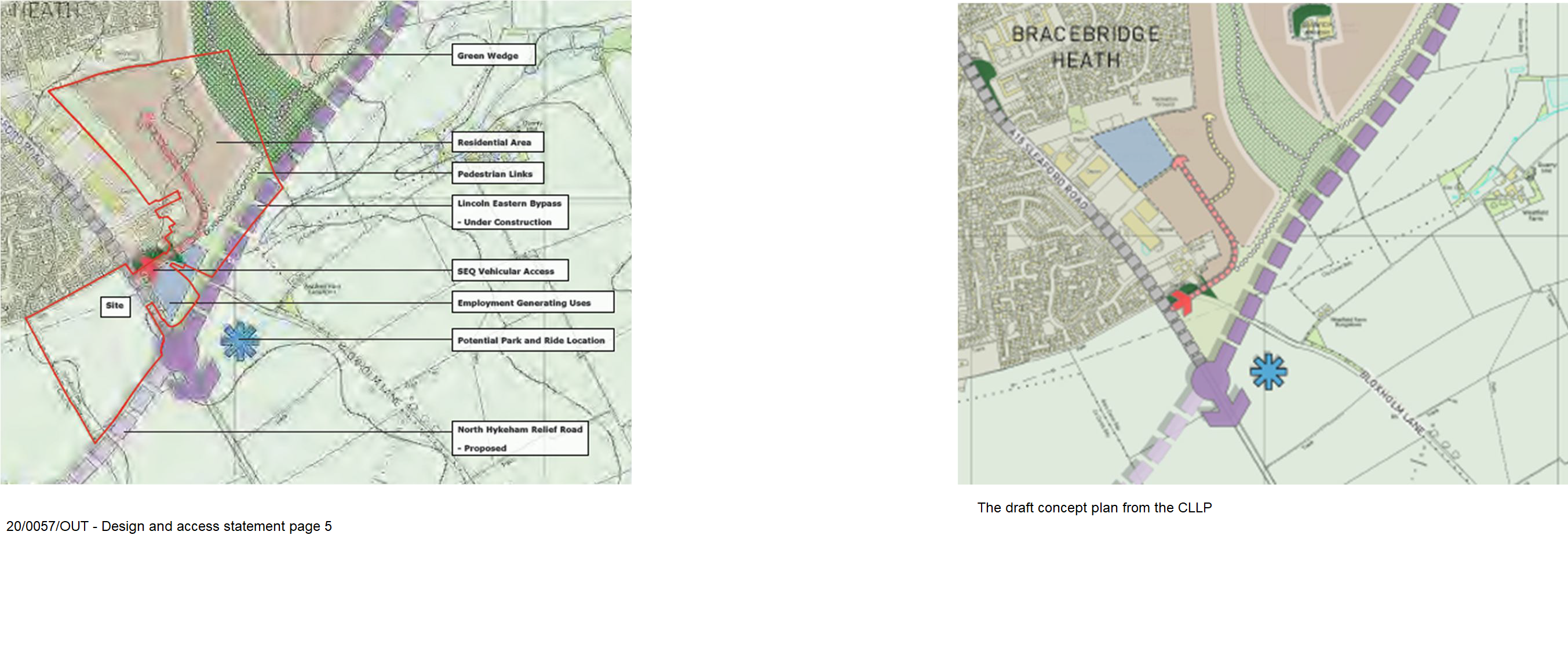
The applicant states that the application is in line with the broad concept plan developed as part of the CLLP.
However, the following aspects are contradictory to the concept plan:
- A primary school site has been added
- An extra area has been added to the SEQ: the area between the eastern bypass, A15 and the footpath over the bypass. This area was meant to be left as a green space buffer zone.
- The wide buffer zone between Bracebridge Heath and Canwick Heath as stated in the CLLP has all but disappeared.
See Image: 20/0057/OUT - Design and access statement page 5/ The draft concept plan from the CLLP
This proposal does not meet the requirements of the CLLP LP28 which states that ‘development of an urban extension must be planned and implemented in a coordinated way, through an agreed broad concept plan that is linked to the timely delivery of key infrastructure. With the exception of inconsequential development, proposals for development within the identified extensions which come forward prior to the production of, and agreement on, a broad concept plan will be refused.’
As the application contradicts the concept plan and does not fit with a masterplan for the area it should be refused.
Phasing
The application indicates that the development will be phased. Without a masterplan, the phasing of developments will occur haphazardly and likely lead to disaggregation to avoid the implementation of infrastructure that is required for larger developments. Key decisions about phasing and infrastructure need to be determined at this stage as part of a masterplan. This should not be left to reserved matters.
Given the scale of the site, it is recognised that there will need to be some phasing and the Parish Council rely on CLLP LP12 to ensure phasing is effective, and essential infrastructure is in place to support the growing population. CLLP LP12 states that ‘consideration must be given to the likely timing of infrastructure provision. As such, development may need to be phased either spatially or in time to ensure the provision of infrastructure in a timely manner’.
The emerging Neighbourhood Plan
Bracebridge Heath Parish Council is currently carrying out a six-week statutory consultation on its draft Neighbourhood Plan. Given the stage at which the Neighbourhood Pan is at, it is felt that this document should be given some consideration in planning procedures.
Highway issues: traffic generation, vehicular access, highway safety
Traffic generation within the SEQ
Traffic generated by this development must be looked at in conjunction and alongside existing traffic issues, and other proposed and emerging developments. Again, without a masterplan there is absence of an overall projection of traffic figures and subsequently any mitigating measures will be disjointed and inadequate.
Highway issues for each development must not be looked at in isolation. The cumulative effect of the developments in generating traffic will serve to create a very congested road network. An overall highway plan needs to be developed for this area before this application and others are approved.
In absence of a complete bypass and until the North Hykeham relief road is completed, careful attention should be paid to the junctions of the A15 with Broadway and the A15 with Sycamore Grove. These junctions will become access points to rat runs which lead to and from the A607.
Highway network within the development
It is unclear if the streets and shared surface roads are designed to be adopted or un-adopted roads. It is also unclear how they will be managed or who would have ownership and be responsible for maintenance. Some homeowners may have to move their bins an unacceptable distance on the relevant days for emptying by refuse wagons which will also lead to large and unsightly bin collection areas. Parish Council requests that all roads are built to an adoptable standard.
At the present time the school access road is very close to the only entrance to the eastern side of the development. This will cause safety issues. Despite all alternatives, it is inevitable that parents will drive their children to school. There is nowhere for parents to drop off children therefore this road and the surrounding residential streets will become clogged up twice a day.
Where is the provision of visitor parking possibly in the form of laybys to prevent on street parking and allow the free flow of traffic and emergency services?
Highway safety and access
The position of the roundabout so close to the large eastern bypass roundabout will cause congestion problems at peak times during the day. This congestion will cause tailbacks into the residential areas and bypass. The pedestrian/cycle crossing of the A15 is welcome but will cause additional tailbacks especially as its position is so close to the new roundabout.
The position of the traffic lighted crossing next to the roundabout may cause safety issues. Car drivers may not notice the crossing point and vehicles often accelerate as they exit the roundabout.
No footpath has been provided on the western side of the A15 to the proposed roundabout. A crossing needs to be provided to the north of Sycamore Grove or the footpath needs to be extended to reach the western side of the development.
The footpath on the eastern side of the A15 especially south of the Churchill Industrial estate is extremely narrow and next to the road. This is unsuitable and dangerous for pedestrians who are elderly/young especially with the number of lorries that use the road and the air drag/turbulence that they cause. This footpath would need to be improved as part of any development.
The safety of existing junctions with the A15 needs to be assessed as part of this application. There are already issues for vehicles exiting the Sycamore Grove and Broadway junctions onto the A15. It is not acceptable to rely on the North Hykeham relief road to alleviate this problem as it will be a considerable number of years before this comes to fruition.
A single point of access is inadequate for the size of the developments. Having only one access road from the development to the west, and one to the east, will cause problems with egress and access particularly at peak times. There will potentially be up to 1500+ cars trying to exit in addition to traffic generated from the business site and the school. This will cause pollution, noise and significant delay for residents.
A single point of access creates risks for emergency services who may not be able to adequately access the development. There being no alternative route, if an incident blocks the exit / entrance from either the western or eastern development there will be significant problems of delay.
Travel plan
It is essential that the travel plans for this site and other emerging developments are robust, accurate and can deliver their aims. There are a number of errors in the travel plan and many aspects cannot be delivered at present and will be dependent on future developments. Without an approved masterplan or overall strategy, the travel plans for all emerging developments will fail. As it stands, the potential for Bracebridge Heath and the new Canwick Heath to become gridlocked at least twice a day or more is highly likely.
This travel plan should be looked at in conjunction with all other emerging developments including the Linden development and land north of Canwick Avenue. An overall plan needs to be created to ensure that the objectives for each development complement each other and work to the benefit of the village. There is potential for delivery of much more ambitious objectives if these developments can work collectively.
Cycle-ways
The provision of cycle-ways throughout the site is welcomed, however they are cycleways to nowhere. A contribution is needed to ensure cycleway continuity. The current application does not conform to the requirements of the CLLP LP30, which states that developments should provide ‘strong connectivity within the development and to the City Centre and adjacent communities through high quality, safe and effective pedestrian and cycling links.’
The application states that it would take 11 minutes to link with the cycle-way network in Lincoln. This is not true for the reverse journey back to the development, as Cross O’ Cliff Hill has a gradient of 12.7% (height increase of 62m in 1.1km). It is impractical to assume that this connectivity is adequate. (Source: https://veloviewer.com/segment/1137952/Cross+o+Cliff+Hill)
The application is contrary to CLLP LP13 which states that all development proposals should ‘prioritise schemes that complete gaps in the network, especially those that will encourage more local walking and cycling journeys’; and ‘deliver networks and facilities for walking and cycling, which are appropriately linked and integrated into the wider transport network’
Existing services, errors and misleading information
- There is little incentive to use existing services particularly as the last bus from Lincoln to the village is at 6.15pm. Not all the buses travel all the way to Grantham.
- Services 537 and N70S are school services. These are unreliable as a means of regular transport. They are generally full to capacity of school children and only run during term time.
- Services M1 and M2 serve only particular factories and only run at shift change times.
- Services 33A and 44A run only once a week.
- The cost of the bus service is prohibitive compared to a car particularly if there is more than one person travelling.
- The distance people to the nearest bus stop from the development will be prohibitive to anyone with mobility issues including the elderly or young children.
- Cycling and walking into Lincoln may be feasible but the obstacle is the two hills (Cross O’ Cliff and Canwick) to re-enter the village.
- On page 2 of the travel plan it states that travel habits will be monitored. This is of no use unless success criteria are included and a means of achieving that success is recorded. Unless any interventions are planned monitoring travel habits is pointless.
- It is not feasible to rely on online shopping as a method of reducing traffic. Each delivery will mean traffic movement throughout the village and a development will never be entirely reliant on online services.
- The lack of footpaths and cycle-ways from the site limit the use of alternative transport from the estates. These will need to be upgraded or put in first before the travel plan has a chance of working.
- Travel by rail from Lincoln to other areas is possible but to access the train service will facilitate the use of a car as the bus service finishes too early to connect the public transport.
- Accidents on the A15 have been limited partly due to the lack of pedestrians on the eastern side of the A15. An increase in pedestrian use from the new development will likely bring about an increase in the number of accidents.
The proposed plans are in contravention of CLLP LP13 which states that all development proposals should ‘assist in the implementation of infrastructure which will help all communities in Central Lincolnshire, including people living in the villages and small settlements, to have opportunities to travel without a car for essential journeys’
Air quality, noise and disturbance
The new development may bring in excess of over 1000 new cars using a single point of access. At peak times of the day the traffic will be extremely heavy causing congestion and pollution. The proximity of the school next to the single access point for the eastern side of the development and the bypass is not suitable due to the level of air pollution. Air conditioning and filtering will be needed for the school buildings as windows will not be able to be opened.
Housing situated near the entrances to the estates especially the western side including the proposed care home will need mitigation against the effects of pollution. Air quality is already a problem in Bracebridge Heath with the junction of the A15 and A607 having the second worst air quality in the area. The additional traffic caused by this development will increase standing traffic throughout the village and particularly at the lights at the junction of the A15/A607. This will not be mitigated by the Eastern bypass as the access point that will be used is on Sleaford Road necessitating travel through the village.
Whilst the application has considered the effect of noise from the eastern bypass and the existing industrial units, it has failed to consider noise and disturbance from RAF Waddington. Engine testing is located at the northern end of the base in addition to the 24/7 air ambulance service from the nearby site.
Hazardous materials and contaminated land
The applicant notes that the area has levels of radon gas and states that appropriate action will be taken. What is this action and will it apply to all buildings?
Other areas of potential contamination have not been recognised in the application:
- The north-western edge of this site is next to the ‘Hump’. The ‘Hump’ was once a limestone quarry with a lime kiln but it is now filled with clinical waste including arsenic and heavy metals and cannot be disturbed. It is not known if any leaching has occurred.
- The whole area to the east of the A15 was RAF Bracebridge Heath and prior to that Robey’s airfield and testing area. This area could contain contaminant and does require a full investigation into possible contamination.
Business / employment areas
The concept plan has an industrial area behind the present Sleaford Road industrial area as part of the 7ha area in the SEQ. It has been recognised since at least 1966 that the area behind the Sleaford Road Industrial Site is to be used as an extension to that site. To remove that provision for an extension seriously limits this site, its future development and viability.
The area of land allocated within the CLLP for employment provision is a total of 7ha. This application provides just 2.2ha. The class C2, A and D categories provided within this application are contrary to CLLP LP5 which states that Class B uses will be supported in this area.
The proposal outlines an area of land for business use between the eastern and western residential areas. This area of land is identified as part of the green buffer zone in the concept plan for the CLLP and should not be built on.
Access to the business area in the proposal is not suitable as it is a shared access with the residential development and school site on the eastern side. The application states that there is 500m2 business space. A retail unit of this size will create unfair competition with the retail units in the centre of the village and may result in the loss of the village centre. Due to its position and lack of bus routes the vast majority of visitors to any retail facility would be by car and not by cycle or walking.
Consultation carried out with businesses for the development of the Neighbourhood Plan has shown that businesses like their current position within the village and would like the opportunity to expand in this location. This is identified in Section 11, Policy 9 of the draft Neighbourhood Plan.
Care home
Anecdotal evidence suggests a care home is needed within Bracebridge Heath. However, the positioning of this care home is inappropriate. Social inclusion is almost impossible from this location and will lead to residents feeling isolated from the village.
A care home and business centre don’t tend to be compatible for a shared site. The business may result in unacceptable levels of noise and disturbance to care home residents. Moreover, the area proposed is not designated in the SEQ, draft concept plan or in emerging Neighbourhood Plan as a development area.
The Parish Council is keen to explore the possibility of locating the care home on the western side of the development where it will be more conducive to a peaceful position. On the western side, the effect of noise, air pollution and continual traffic would be minimised.
Infrastructure - public drainage, water systems, electricity
Consultation and investigation of issues should take place with relevant authorities before a decision is made on this application. Parish Council requests that the following are carried out before any decision is made on this application:
- Comprehensive consultation with Anglian Water to determine the location of pipelines at the development site.
- Consultation with Anglian Water to determine and mitigate issues with foul and surface water.
- Comprehensive consultation with the National Grid regarding electricity cables at the site, and alongside the site towards RAF Waddington.
- Consultation with Anglian Water regarding clean water pressure. Application 15/0477/OUT indicated that clean water pressure was at its limit. This application, alongside 16/1564/OUT will put additional pressure on the system.
These matters may affect the final layout of the development so the extent of the issues should have been determined at a pre-application stage. A decision should not be made on this application until these matters are appropriately investigated. This cannot be left until a reserved matters stage.
Although there is a slight gradient to the sites there is no indication of whether there is sufficient flow to allow for gravity fed sewerage flow or where the sewerage will need to be pumped. Where will the sewers connect with the main sewage system?
SUDS
The permeability and infiltration rates of the ground in this area is variable. No investigation or documentation has been provided to ascertain the infiltration rates or outline who is responsible for maintenance. This information is needed at the outline planning stage. The Parish Council requests that this application is refused until the applicants have consulted with Anglian Water and they are satisfied with the outcome.
Surface runoff is of considerable concern to nearby villages on the lea (east) side of the escarpment along the spring line. Until the effect of surface water discharge has been investigated and satisfactorily resolved, this application should be refused.
Deficiencies in social facilities
The local doctor’s surgery is understood to be full for new patients. This means that the surgery will struggle to accommodate extra patients, even with the benefit of a S106 agreement. To access surgeries furtheraway would involve car travel or in many cases catching two buses.
There are no dentist facilities within Bracebridge Heath.
Many of the schools mentioned within 2 miles of this site are not easily accessible except by car as they would require 2 bus journeys to access them. There is a shortage of secondary school places within the area. This development will require approximately 230+ places at a secondary school.
CLLP LP 12 states that ‘planning permission will only be granted if it can be demonstrated that there is, or will be, sufficient infrastructure capacity to support and meet all the necessary requirements arising from the proposed development. Development proposals must consider all of the infrastructure implications of a scheme; not just those on the site or its immediate vicinity’.
The proposed school
The shape of the proposed school site is irregular and not easily adaptable to site school buildings and the necessary outdoor space. The site is the minimum area required for a two-form entry and there is no room to expand should a three-form entry be required.
The siting of the new school alongside a busy road will bring problems of security, noise and air quality as already mentioned. Additional natural screening should be incorporated with these plans. Therefore, 1.8ha is not sufficient as landscaping to minimise noise and pollution around its perimeter will take up a considerable area and limit the usefulness of the site.
Issues with parking are a concern including parents attending the site twice a day and the lack of allocated parking for staff to prevent on-street parking in the adjacent residential development. The proximity to three listed buildings will also bring additional costs and restrictions.
If a school is required within this application, Parish Council is keen to explore the possibility of siting this on the western side of the development.
Recreational green areas
Bracebridge Heath already has insufficient public open space for its population. Areas counted within the assessment for existing green space for this application include the St John’s hospital consecrated cemetery and the ‘Hump’. These areas have limited use as a recreational space and should not be considered as main thoroughfares due to the number of burials in the cemetery and the contaminants contained within the ‘Hump’.
There is no information on the management of green areas in perpetuity. The Parish Council is opposed to management companies taking responsibility for maintaining green spaces and recreation areas and recommends that this responsibility is devolved to the Parish Council.
Council is concerned that the recreation areas are insufficient in size to accommodate organised games such as football, rugby etc. This type of provision is integral to a development of this size. More information is required before a decision can be made on the appropriateness of the green spaces. Council refers back to the requirement for a masterplan.
The amount of useable land set aside as public open space (discounting the buffer zones which will be used to mitigate against noise and air pollution) is insufficient for a development of this size. The application proposes 4.9ha of open space for a projected population of 2900. This is contrary to the CLLP. The quantity standards referred to in CLLP LP24 equate to recreation provision for this development of 7.54ha.
Open space type
- Strategic formal playing fields 3.19ha
- Local usable green space rural towns and villages 4.35ha
- Total 7.54 ha
The application does not meet the requirements of CLLP LP24. This policy states that ‘Open space, sports and recreation provision requirements should: be multifunctional, fit for purpose and support health and outdoor recreation; consider the context of any existing provision and maximise any opportunities for improvement within the wider area where these are relevant to the development of the site; when new provision is provided, have appropriate mechanisms secured which will ensure the future satisfactory maintenance and management of the open space, sports and recreational facility’.
The CLLP open space provision standards also outline that equipped play parks are required within 5 minutes walking distance. There are none planned within this application.
The green buffer zone provided within the CLLP draft concept plan between Bracebridge Heath and Canwick Heath has all but been removed and replaced by residential units.
Community buildings/indoor games areas
Bracebridge Heath is already short of community facilities and indoor leisure facilities for its existing population. The proposal offers no additional community buildings despite a proposed increase to the population of around 50%. This large development must incorporate community buildings for use by Bracebridge Heath residents. CLLP LP15 states that, ‘where new community facilities are deemed necessary as part of a wider development proposal… developers will be expected to provide such relevant facilities either directly on-site and/or off site, through a financial contribution, either alone or cumulatively with other developments.’
Parish Council would be happy to explore the possibility of supporting the expansion/ development of the existing community buildings to help meet this requirement.
Allotments and gardens
The density of housing proposed will limit the size of gardens. This is contrary to the emerging Neighbourhood Plan.
With the number of dwellings proposed there will be a need for more allotment space and possibly a community orchard in an easily accessible area for these developments. This type of provision should be considered as part of a s106 agreement.
Layout and density
Density
The western section has 344 dwellings proposed. In the CLLP, site CL415 (11.82 ha), is planned to have 241 dwellings. The applicant is planning an increase of 43% for this area which is in contravention of the CLLP.
The Housing and Economic Land Availability Assessment (HELAA) Site Review 2019 shows that the eastern side of this development was planned for 527 dwellings. With the addition of a primary school within the area for the site there should be a reduction in the total number of dwellings proposed.
Without a masterplan, densities cannot be monitored to ensure that each site and phase builds only its allocated number of dwellings. The area is at serious risk of overdevelopment and the application is in contravention to the emerging Neighbourhood Plan.
There is a discrepancy in the total number of dwellings planned for this site. In places, 1156 is mentioned and in others a total of 1200 dwellings is noted. Which is the correct number?
Council strongly objects to the density of the housing which is that of a town not a large village. Long terraces or 3 or more storey houses are not appropriate. Concern is expressed over the high density of buildings and the effect it will have on the mental health of the occupiers.
Housing densities of the size applied for by the Church Commissioners would, if applied to the rest of the SEQ, give at least double the number of dwellings required to be delivered by this SUE. Therefore, the densities should be reduced so not to put undue burden on Bracebridge Heath and giving an unfair distribution of housing throughout the SUE.
The information about current densities in Bracebridge Heath is misleading, particularly densities stated for the Victorian/Edwardian terraced housing. The housing densities to the west of Grantham Road are all around 14-16 houses per ha. The majority of housing between the A607 and A15 are in the mid 20 houses per ha. The Sycamore Grove and St John’s hospital estates may have areas in them that may exceed 30 houses per ha.
The Church Commissioners have excluded density information for the latest approved development off Westminster Drive. The housing density approved in this development is 21 dwellings per ha when open space is included (26 dwellings per ha when open spaces are not included). Parish Council expect that a similar density of housing be incorporated for 20/0057/OUT.
The eastern side of the development should have a lower density of housing as it approaches the green buffer zone so as to help increase the feeling of a separation zone. The same lowering of the density on the western estate should occur on its southern, eastern, and western edge so as to soften the change from countryside to village. The high density of housing near the entrances to both sides of the development will create a cramped, enclosed feeling.
Consideration needs to be given to the proposed residential area behind the existing industrial units off Sleaford Road. The noise and air pollution from this area is at times high. CLLP LP26 states that ‘Proposals for development adjacent to, or in the vicinity of, existing 'bad neighbour' uses will need to demonstrate that both the ongoing use of the neighbouring site is not compromised, and that the amenity of occupiers of the new development will be satisfactory with the ongoing normal use of the neighbouring site’.
Council note that there is a lack of one storey or one and a half storey housing in this application. Three storey housing is undesirable and contravenes the emerging neighbourhood plan.
Affordable Housing
There is no evidence of affordable housing within this application. Parish Council believe that this needs to be considered in the outline planning stage to ensure that each phased application does not circumvent its requirement for affordable housing. Without a masterplan to control this requirement, careful attention will need to be paid to each phase as it is brought forward for permission.
Climate change
Council welcomes the inclusion of electric plug in points but will this be for all households? The Bracebridge Heath emerging neighbourhood plan states how many parking spaces are needed per household. All houses will need charging points. This was also emphasised in the NKDC Low Carbon Plan 2013-2020. To achieve the targets set in this plan, proposals will need to include additional measures for carbon efficiency.
There is no indication of other climate change features in the application or how the developer will embrace aspects of design such as solar panels, cycle storage, heat exchangers, rainwater harvesting etc. This needs to be embraced now and not left until the reserved matters stage.
Effect on listed buildings
The amount of traffic that will pass within metres of this grade two listed wall, farm house and farm buildings daily will be well in excess of 1500 daily with the potential of stationary traffic at peak times. The pollution levels cause by this amount of traffic will have a detrimental effect on the listed limestone wall and manor house as well as the listed farm buildings (brick and limestone built).
There is potential for archeological remains to be on site and the presence of former field systems require further archeological assessment of the site to take place.
The CLLP LP25 states that ‘development affecting archaeological remains, whether known or potential, designated or undesignated, should take every practical and reasonable step to protect and, where possible, enhance their significance. Planning applications for such development should be accompanied by an appropriate and proportionate assessment to understand the potential for and significance of remains, and the impact of development upon them.’
Views
There are important views over the escarpment lee slope across the River Witham valley to the Lincolnshire Wolds which can be clearly seen from this site. The layout of the eastern side of the development does not retain a view through to the Wolds. This contradicts CLLP LP17 which states that, ‘all development proposals should take account of views in to, out of and within development areas: schemes should be designed (through considerate development, layout and design) to preserve or enhance key local views and vistas, and create new public views where possible’
The proposed development will also have a negative impact on the view of the Cathedral as you enter the village via the A15.
Nature conservation interests & biodiversity
As stated in the report by David Broughton the surveys need to be repeated at the correct time of the year. No lighting scheme for open areas has been produced and will be needed before development takes place. There is nothing within the proposals to encourage wildlife to the new area and schemes such as wildlife corridors need to be incorporated. Removal of any hedgerows must be replaced by the planting of new native species hedgerows preferably more.
In summary, Bracebridge Heath Parish Council request that the Planning Authority refuse permission for application 20/0057/OUT, at least for the following reasons:
- Lack of consultation with relevant bodies and authorities and lack of reliable evidence about the viability of key services.
- Too many important matters which could change the layout and designated areas are being left to reserved matters and should be available at this stage of the planning process.
- The application has not taken into account the full effect of traffic from this development and others and included suitable mitigating measures.
- The travel plan is based on incorrect and misleading information.
- The application does not comply with the National Planning Policy Framework including sections on Climate Change, Pollution (Air Quality), infrastructure and integration with the existing community.
From the submitted plans it is clear this application will not help to achieve a truly sustainable urban extension. The lack of a masterplan and overall control is extremely concerning and will lead to a piecemeal disjointed SUE which will result in unacceptable growth that is detrimental to Bracebridge Heath.